What Pidurangala is – a monastery in caves or an ancient Over-the-Horizon Early Warning Radar next to the Sigiriya "Lion's Rock"?
This is a continuation of the :
and
There is an unusual "bald" granite mountain at exactly 1 km distance (by centers) to the rocky plateau of Sigiriya, with flat inclined top of triangle shape, as if it were cut obliquely by the giant knife.
There is a monastery in caves of the Pidurangala Mountain, quite a big cave complex. Though the walls of the caves have been reconstructed the tell-tale signs of early civilization are evident. The face of the rock is carved to form grooves to prevent rain water from directly falling onto the caves. Furthermore, a rock inscription written in early Brahmi script links the cave to Lord Pussa and has been dated to 3 BC - 1 BC. This proves that the caves at Pidurangala were inhabited prior to King Kashyapa's era.
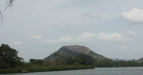
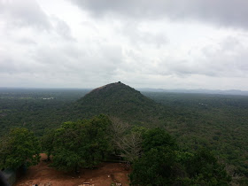
Here's how it looks like from the top of the rock of Sigiriya:
We can't see its flat inclined granite top of triangle shape from Sigiriya, because it is aimed in the other direction (away from us and to the left), and located on the back side of the mountain. But you can look at Google Earth screenshot (Pidurangala Mountain with sloping flat is highlighted by the yellow circle.)
Also you can see "the balancing stone" on the top of the Pidurangala mount. The Guide said that the "balancing stone" is installed in unstable condition and could easily be forced to swing with small power as a pendulum. As before, the Guide said that this "balancing stone" was intended to use as a weapon, to throw it on the heads of attackers, if necessary. This is nonsense, because even with rough assumption, weight of this stone is more than 5,000 tons and even currently it is impossible to install it there with our modern technologies, not to mention slaves with ropes and wooden sticks which only were at Kashyapa's disposal.
Do you remember the "stone on columns" placed near the "lion's paws" of Sigiriya? Very interesting coincidence… There are two mountains with the same high, with two "balancing stones" of thousands tons weight on each.
Assumption: from the modern point of view, these stones make sense only as seismometers (seismographs), sensors of seismic vibrations. Somehow, it was very important for ancient builders of Sigiriya, to be sure, that there were no so powerful earthquakes which were able to change geometric parameters (orientation) of mountains. Why? Because mountains could be used possibly for some very precise tasks…
Let's investigate geometrical parameters of the mountain.
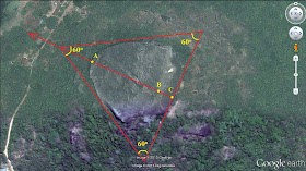
If Google Earth tells us true, parameters of the Pidurangala Mountain top are following:
- Top of the rock fits within an equilateral triangle;
- elevation at point A = 252 m, at point B = 309 m, so h = 57 m;
- AB = 160 m. From point A to point B the plane of the rock has a uniform slope. There is no slope from point B to point C - plane is parallel to the Earth's surface.
I calculated the angle of the plane incline:
Cosec α = 160/57 = 2.8070175
So, α = 20.87 degrees (or 0.36425 radian) ≈ 21 degrees.
There is some thought of known to us modern analogues crossed my mind. There is a modern object identical (similar) to shape of the Pidurangala Mountain top:
 |
| Photo of Signals intelligence radar at Ovidiopol-2, Odessa region, Ukraine. Used to be a GRU's top secret object during USSR times. |
Assumption: thus, it can be assumed that the slope of the top of this rock used to be a basis for large antenna reflector, which could be:
1. The radio telescope designed for tracking space objects, or, equally likely:
2. Part of the over-the-horizon radar complex for surveying of space in the direction of Egypt (North Africa) and on, right up to the both Americas. Or part of the early warning radar system allowing defenses to be alerted of missile launches. Or part of Signals Intelligence system. There is its current analogue - antenna for signal intelligence that looks similar - a huge sloping plane (placed at Ovidiopol-2, Odessa region, Ukraine, it used to be a GRU's top secret object during USSR times.)
3. Or all of these at the same time.
In order to determine in which direction this antenna could be aimed, I worked little bit with Google Earth and found the following: briefly, the antenna was designed to control the airspace over the Arabian Peninsula, North Africa, Atlantic Ocean and Americas. Partly or entirely.
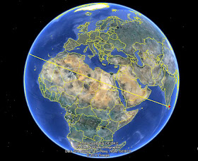
If you draw a straight line on the axis of symmetry of the plane (antenna reflector) from higher to lower its points and on, you'd get the following result:
As the starting point I accepted the point behind the rock with coordinates: 7⁰57'52.40" N and 80⁰45'56.01'' E. Drawing a line further, I discovered that the line passed through Oman, Saudi Arabia, Egypt.
The line crossed the Nile River in Egypt at coordinates: 24⁰14'49.92" N and 32⁰52'35.60" E. Distance from that point to the pyramids on the Giza plateau is 685 km as the crow flies. The distance from this point to Sigiriya is 5,397 km. Thus, the deviation at Giza is not more than 7⁰ from our line's direction, so it definitely gets into the working sector of antenna. Although, there might be some inaccuracy... But there is nothing completely perfect on Earth… :-) Further the line passes through Algeria, picks Mauritania and through Western Sahara comes out onto the Atlantic Ocean.
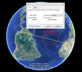
Passed over the ocean, the line rests almost on the joint between Americas. In my case the line passes over Trinidad and Tobago, Venezuela, and Colombia (right above Bogota). I stopped the line at coordinates: 2⁰26'05.49" N and 78⁰08'09.02" W.
An interesting observation: what if the radar was directed to Atlantis ("island of Atlas"), a legendary island first mentioned in Plato's dialogues Timaeus and Critias, written about 360 BC?
According to Plato, Atlantis was a naval power lying to the west of the "Pillars of Hercules" (in front of Strait of Gibraltar) that conquered many parts of Western Europe and Africa 9,000 years before the time of Solon, or approximately 9600 BC. After a failed attempt to invade Athens, Atlantis sank into the ocean "in a single day and night of misfortune".
In result of calculation, it turns out that the angle between direction from Sigriya to the most southern point of South America up to the northernmost point in North America is about 60⁰, i.e. if the working sector (sector review in the horizontal plane) of the antenna was not less 60⁰, it allowed to control all airspace and outer space over the entire territory in that direction.
Somebody could say that it can't be the radar, because radio waves travel in a straight line and cannot go round the earth. But over-the-horizon radars (OTH) use ionospheric reflection. Radio shadow problem for them does not exist at all. OTH is able to detect targets at very long ranges, typically up to thousands of miles.
For example, Russian Duga-3 (Russian: Дуга-3, 5Н32) OTH was able to detect launch of the subsonic cruise missile "Tomahawk" from the submarine in the Atlantic Ocean. It sounded like a sharp, repetitive tapping noise, at 10 Hz, so the Americans called it Woodpecker.
The structure of Duga-3 included three stations:
- In the area of Chernobyl (Ukraine, Chernobyl 2.) The station was constructed near the Chernobyl nuclear power plant due to its high energy consumption. Its State tests after modernization in 1985-1986 failed on April, 26 1986 in connection with the accident at Chernobyl.
- Near Nikolayev (Ukraine), currently dismantled.
- In the Bolshaya Kartel village (Khabarovsk Territory), next to the Komsomolsk-on-Amur, de-alerted of November 14, 1989 due to changes in the international situation and currently dismantled.
Fields of view of Duga-3 OTH stations:
 |
| Fields of view of Duga-3 OTH stations |
For example, here is a picture of similar U.S. OTH radar in Nekoma, North Dakota (although it was a poor excuse of Duga-3):
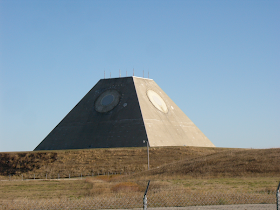 |
| Stanley R. Mickelsen Safeguard complex in Nekoma, North Dakota |
Somebody also could say that it makes no sense to use such a great rock as a base of metal reflector of antenna. In my opinion, on the contrary, all is logical. If I have a tool, with one stroke of which I can cut to half the whole rock, I'm not going to bother with a long and troublesome installation of numerous metal trusses of the antenna with a height of several hundred meters. Moreover, a stone rock, as a basis for installation of antenna's metal reflector, much stronger than structure of metal trusses. So everything seems very clear and logical – constructing such a stone base is much easier, safer and better.
Also I would say couple of words to those, who confused with irregularities of antenna surface. In fact, it doesn't matter - stone surface by itself was hardly used as a reflector. So it doesn't have to be perfectly flat. Most likely this was the basis on which a metal reflector was mounted. In addition, there is another explanation of irregularities of a "rocky antenna" surface. It is clear that such objects in wartime are the priority objectives for the first, prevention strike. Taking into account the fact that the ancient city of Mohenjo-Daro (Pakistan) was destroyed in 1,900 BCE by the impact of a nuclear weapon (or weapons with similar affecting factors), we can easily assume that the ancient civilization of which we are here concerned, were at compete and sometimes quarreled.
I do not insist that the "rocky antenna" was destroyed by nuclear explosion, no. There are no evidences for this. But if war comes, it had to be destroyed (damaged) in the first place - it's a fact. The rest was done by time and rains.
In addition, I would say that two seismic sensors ("stone on columns" and "balancing stone" of thousands tones weight) are the best evidences of my "stone antenna" theory. In this version they make sense - to understand whether the situation has changed, and therefore the characteristics of the antenna (orientation, angle, etc.) as a result of earthquakes, or not. Especially if you visit the site after a long absence, for example - if you find a stone fell on its side, it 100% needs a major overhaul. If the complex was intended for resort only, there would be no sense in such sensors and they simply would not exist.
Thus, I dare suggest that the "rock antenna" at Sigiriya was designed to control air space not only above the Arabian Peninsula and North Africa, but possibly above Atlantis and Americas. The object of Sigiriya looks in this light not only as a comfortable place for leisure and entertainment, but also as a strategic object of special importance to signal intelligence or (and) missile and space defense of the ancient civilizations.
So, there is a sense to look for ancient spacecraft launching sites in that direction. Launchers of intercontinental missiles with nuclear warheads could hardly survive to nowadays. Although if they built them as silo launchers, as we are doing now (so the rocket most protected), the silo launchers could survive to modern times, if they had been carved in granite.
Interesting details: Sri Lanka is mentioned in the Ramayana and the Mahabharata, Sanskrit epics of ancient India, as the island kingdom of Lanka, ruled by Ravana, the main villain in the Ramayana.
The oldest preserved parts of the text officially dated around 400 BCE, though the origins of the story probably fall between the 8th and 9th centuries BCE. Mahabharata gives a description of the continents of the Earth, the other planets, and focuses on the Indian Subcontinent and gives an elaborate list of hundreds of kingdoms, tribes, provinces, cities, towns, villages, rivers, mountains, forests, etc. of the (ancient) Indian Subcontinent. It also explains about the military formations adopted by each side on each day, the death of each hero and the details of each war-racings.
Descriptions of some Mahabharata battles contain evidences of the possible use of nuclear weapons, with all of its destructive factors.
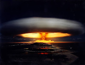
They say that during first atomic weapons test (July 16, 1945, codename "Trinity"), father of atomic bomb Robert Oppenheimer, shocked by terrible death power of his "child", had been reciting verses from the Mahabharata on Sanskrit:
“…Gurkha, flying a swift and powerful vimana,
hurled a single projectile
charged with the power of the Universe.
An incandescent column of smoke and flame,
as bright as ten thousand suns,
rose with all its splendour.
It was an unknown weapon,
an iron thunderbolt,
a gigantic messenger of death,
which reduced to ashes
the entire race of the Vrishnis and the Andhakas…"
Of course, these objects cannot be considered separately from other similar, they should be considered only in comprehensive approach, as they were supposed to be part of a huge system located over large areas - in different countries and possibly, even continents. From this point of view, to test this theory, it is useful to map these ancient structures and try to establish a link between them.
A little bit of history and interesting facts:
When archaeologists had excavated the city of Mohenjo-Daro (translated as "Hill of the dead", destroyed about 3,500 years ago) in the 19th century, they found a lot of skeletons just lying on the streets, some of them were holding hands as though they were surprisingly took by some danger. These skeletons are the most radioactive from ever found, on a par with those found in Hiroshima and Nagasaki.
Ancient cities whose brick and stone walls literally turned into glass and melted together, can be found in India, Ireland, Scotland, France, Turkey, Russia (Karelia) and other places. There is no other logical explanation of melting of stones of fortresses and cities but an Atomic blast, or some very powerful weapon with effects similar to a nuclear explosion. To reach such results in any other way (the more conventional open fire) would not have been possible at all.
There are whole layers of fritted clay and green glass found among the ruins In Mohenjo-Daro, perfectly planned by a grid, with city water supply and sewer system, advanced than in Pakistan and India today, city, which according to the official story simply would not exist in such an ancient and wild times.
Apparently, sand and clay initially were melted and fused under the influence of extremely high temperature, and then instantly hardened. The same layers of green glass appeared in the desert of Nevada (United States) after every nuclear explosion.
The analysis of samples carried out at the University of Rome and in the laboratories of the Italian National Research Council, revealed: fusion happened at 1400-1500 Centigrade's. The temperature during those times can be reached in metallurgical furnace, but never on a vast open area.
If you carefully examine the destroyed buildings, you will see that there is a clear region outlined as the epicenter of explosion, ground zero, where all of buildings were swept away by a "squall". Destroying impact gradually decrease from the center to the periphery. Most buildings have remained at the periphery. In short, the picture is reminiscent of the effects of the atomic bombings in Hiroshima and Nagasaki.
Dating of the destruction of the city (3,500 years ago) is based on the radiocarbon analysis and can produce significant errors in conditions of high radiation (and there they just occured). The radiocarbon method applied by Soviet scientists, showed earlier date of 2,400 b.c.- this is a 4,400 years ago.
Other researchers include Mohenjo-Daro to one of 7 cities of "Rishi", owned by the ancient Empire, which existed in India 15,000 – 12,000 years ago.
So, with the death of Atlantis by the cataclysm in the depths of the named in it honor Atlantic Ocean, and the destruction of Kingdom of Rama by nuclear weapons, our world rolled down to the "stone age" again.
Endless cycles of history ... How many times this has happened before? How many times it will be repeated again and again?
Human memory is short, but so did the short memory of mankind. Oblivion is a most terrible curse, seal of which humanity bears on itself...






Thank you, Vladimir, for your great and thoughtful articles. It is another piece of an awesome "puzzle" of our history.
ReplyDeleteI am convinced our history is not so linear as the contemporary science says. There is so much evidence around the world that there was a civilization of much higher technological level than we would dare to think dating back to 12000 BC.
Thanks again, I am looking forward to read even more from you :-)
Jan
Don Vladimir Kovalev
ReplyDeleteThe Third Secret, (not of Fatima), or the tip of the iceberg, of Sigiriya is now published. Nothing is without a connection to something bigger. Although we often do not recognize him. Only people who have a lot of knowledge and life experience can recognize technical, human and historical and cultural contexts.
You have recognized that a temple is not really such. It can not be a defense site of Prince. He may have only used on his escape. You mention that both rocks were plants, which belonged to a perhaps even greater network of technical equipment to monitor the airspace.
This theory fits well with the stories of Zecharin Sitchin. Whether it was used for radar is, of course, impossible to prove. Sitchin says that the spacecraft had to aim for two mountains and had to steer their spacecraft through them to get on the right pad. Perhaps the cut was a mountain station, widely visible from above, or just as you suggest, a radar. A transmitter, and the radar may have been used together.
permit me to give you an indication of laser reflectors that are on the moon. In a video, a man explains that these reflectors at an angle of 23 degrees to the moon's surface are on the moon. Laser may be used for measuring the distance Earth Moon. Your specified angle of this radar station on the Rock has 21 degrees. This is almost the same inclination, 21 and 23 degrees.
This could be a consideration to take place if were not made from the Moon, or from space, such measurements, or direction finding signals down to earth and there were data reflected back. Lunar Laser Video
http://www.youtube.com/watch?v=LZOtccqbIUI
For us, the readers, it is a gift to be able to read such reports. But for the author himself ...? How would it be if you could write a book about it?
Regards
Josef Bauer
Don Josef Bauer and Jan,
ReplyDeleteActually, when I started to write my Essay of Sigiriya, I haven’t thought about a book. I just couldn’t keep my observations, impressions and assumptions inside and decided to share them, make them accessible for all people around the world, who could find it interesting. Do not judge me harshly; this is my first literary experience.
To tell the truth, my Story hardly shows traditional scientific approach, because sometimes I let myself to make assumptions which stay in more than one logical step from facts.
As a professional analyst which I used to be for some couple years, I clearly understand it and don’t claim my Story to be a scientific work, most likely it is some kind of light reading. In the same time I made some conclusions on the base of my deep and strong convictions that history of humanity has a lot of unsolved inconsistencies between an official versions and many evidences and artifacts found all over the world.
There is a sense to look at unsolved mysteries of the world from the other angle and I am going to do it, all the more Internet makes it easier providing access to enormous amount of information. I will try to analyze information from different reliable sources and put together some puzzles to make a new picture of some interesting places and evidences, inherited from ancient civilizations.
May be, one day I will think about a book… At least the book would be very important part and worthy goal of my life…
One more time I would like to express my gratitude to all the readers, who find my story interesting and inspire me to write more.
mr. vladmir....
ReplyDeleteim from sri lanka....sigiriya is not a king kashyapa's palace...it was build long long time ago by king sinhamukha...then it developed by king ravana with his superior technology..also he has a flying aircrafts calld dadumonara...if you r interested in this just mail me to this chankydbest@gmail.com
This comment has been removed by the author.
ReplyDeleteHi "Zeeker",
ReplyDeleteThanks for your comment. I am not a scientist, it's just my hobby. I treat your country with great respect, because thousands of evidences all around the world show that it might be a cradle of modern human civilization. Moreover, there are many evidences proving existence of great Empire (or Empires) which included territories of Indian subcontinent, Africa and South America…
There is a big problem to find evidences of technologically advanced civilizations that existed about 15,000 years ago, but besides ancient epics like Mahavamsa, Mahabharata, Ramayana etc., there is one important thing proving a fact that this ancient civilization was more advanced than our modern – it is amazing and inexplicable technology of granite stone processing. We have a lot of them. And I saw them while visiting Sigiriya.
It made so great impression on me that I decided share this with other people, who may be interested in real history of human civilization. It is even better, that I am an amateur, not specialist. Because I can look at any problem from unexpected angle and use my imagination on 100%. So, I am going to continue my researches of Sri Lanka history in connection with world history further.
I am very grateful to you and other people, who took time reading my Essay. I would appreciate if you give me some information, description, links, photographs etc. of most interesting and mysterious places and objects which might relate to Kingdom of Ravana or prove assumption of advanced level of development of ancient civilization.
May be you know about star gate in "Ranmasu uyana - Anuradhapura". You'll definitely interest on this. I send link of this post for one of my friend who is extremely keen on this area and he said that he is gonna send you some details about that (coz he is also keen about that and may be he can help you on that :) ). If you are in Sri Lanka don't forget to visit it. and also as you said I'm also not a scientist, in my profession I'm a computer engineer. But this is also my hobby. I'm really glad about you effort.
DeleteOkay, thanks, it would be very interesting. My contact e-mail is shown in my profile. Kindly waiting for an e-mail!
ReplyDeleteHi Vladimir,
DeleteI went through your profile yet couldn't find out your email. Please drop here the mail address.
My e-mail: piastrella.com.ua@gmail.com
DeleteMr.Vladimir kovalev
ReplyDeleteThanks for your article...
You all are doing great with finding mysterious things...
We are Sri Lankan - Sinhalese - Buddhists and we are trying protect our country from Muslims !!
We lost number of ancient pagodas, places(eg-"Muhudu Maha Viharya") because of aggressive Muslims.
Help us to protect our mysterious island.
Hope you will post more articles about my mysterious island.
Thanks,
Janitha
Thank you, Janitha!
DeleteWhen I visited your mysterious Island, I was amazed by greatness of Sri Lanka history heritage and kindness of your people. I had great time there and I am happy that native Lankans may find my modest researches and assumptions quite interesting and helpful.
This comment has been removed by the author.
ReplyDeleteDear Vladimir... We are really thankful read your information about Pidurangala and Sigiriya. As Sri lanka having a long history not any evidence. but there many of place can not understand. . You have done a hobby but great work....
ReplyDeleteThanks a lot..
Chamali Madanayake
Stockholm
Sweden
Thank you, Chami Lanka!
DeleteThank you so much Vladmir, I am really thanking for u to given this kind of view point to the pidurangala and sigiriya, yeh We srilankan had a great history and we all are part of it but unfortunately our great history was hidden from us
ReplyDeleteThank you, Madu!
ReplyDeleteDear Vladimir,
ReplyDeleteI am very thankful for your experiment and logical explanations.
i think you will be pleased to hear the below.
It is said that some sort of nuclear weapon or a similar weapon has been used in a clash in the era of Ravana in southern area of Sri Lanka. It has been scientifically proven that some sort of a huge explosion has happened in the Wedasiti Kanda (Wedihiti kanda), a mountain located in Katharagama area in southern Sri Lanka.
I think this is something similar to your explanations.
Thanks
Shehan
Dear Vladimir,
ReplyDeletesrilanka is the lowest gravity point on the earth
http://news.bbc.co.uk/2/hi/8767763.stm
Dear Vladimir,
ReplyDeleteI am really proud to be a Sri Lankan and Thank you very much....... I am also interested in these things since last year.... I can see a combination between the various cultures around the world..
Just like the similarity of the Lion's paw on Sigiriya & the great sphinx... I like to increase my knowledge by following you.. Thank you Vladimir
If you are on Facebook or Google+, then you can read my analysis of the name KODESCH which is said to be Jewish. But the name is much more than that and it leads to the garden of Eden.
DeleteDear Vladimir,
ReplyDeleteI am really proud to be a Sri Lankan and Thank you very much....... I am also interested in these things since last year.... I can see a combination between the various cultures around the world..
Just like the similarity of the Lion's paw on Sigiriya & the great sphinx... I like to increase my knowledge by following you.. Thank you Vladimir
Seshendra Sharma , scholar - poet of 20th Century says the Mahabharata is a replica of , one to one reflection of the Ramayana.
ReplyDeleteShodasi : Secrets of the Ramayana
Author : Seshendra Sharma ( http://seshendrasharma.weebly.com)
For reviews and other details : www.facebook.com/shodasi/
to your esteemed site.
Thanks / Regards
Time have a answers...Good work..
ReplyDeleteim so happy to read my thoughts in such elegant details.
ReplyDeleteI also believe we are currently under the influence of very strong force of intelegence which can be observed in the rapid transformation and development of technology...
but what bothers me is if we are not the only universe and there are so many similar earth like planets ......... then there is a lot facts being hidden to us... but we get the message and hints through certain movies.
Mr Kovalsky Im truely impressed with your findings and sharing it with us.
Cheers
Sujeevan
Dear Mr Kovalsky
ReplyDeleteStanley R. Mickelsen Safeguard complex in Nekoma, North Dakota and the Ancient Pyramids, could they be built to do the same functions, or were the Pyramids designed to communicate out into space ?
REgards
Sujeevan